Tirana Green Belt
2016 - Green Belt, Tirana
Status:
Thesis, Academic Project
Design Team:
Francesca Calace, Maurizio Campanella, Francesca Avella, Nicola Boccardi, Pasqua Clemente, Maria Giovanna Caragnano, Valeria De Troia
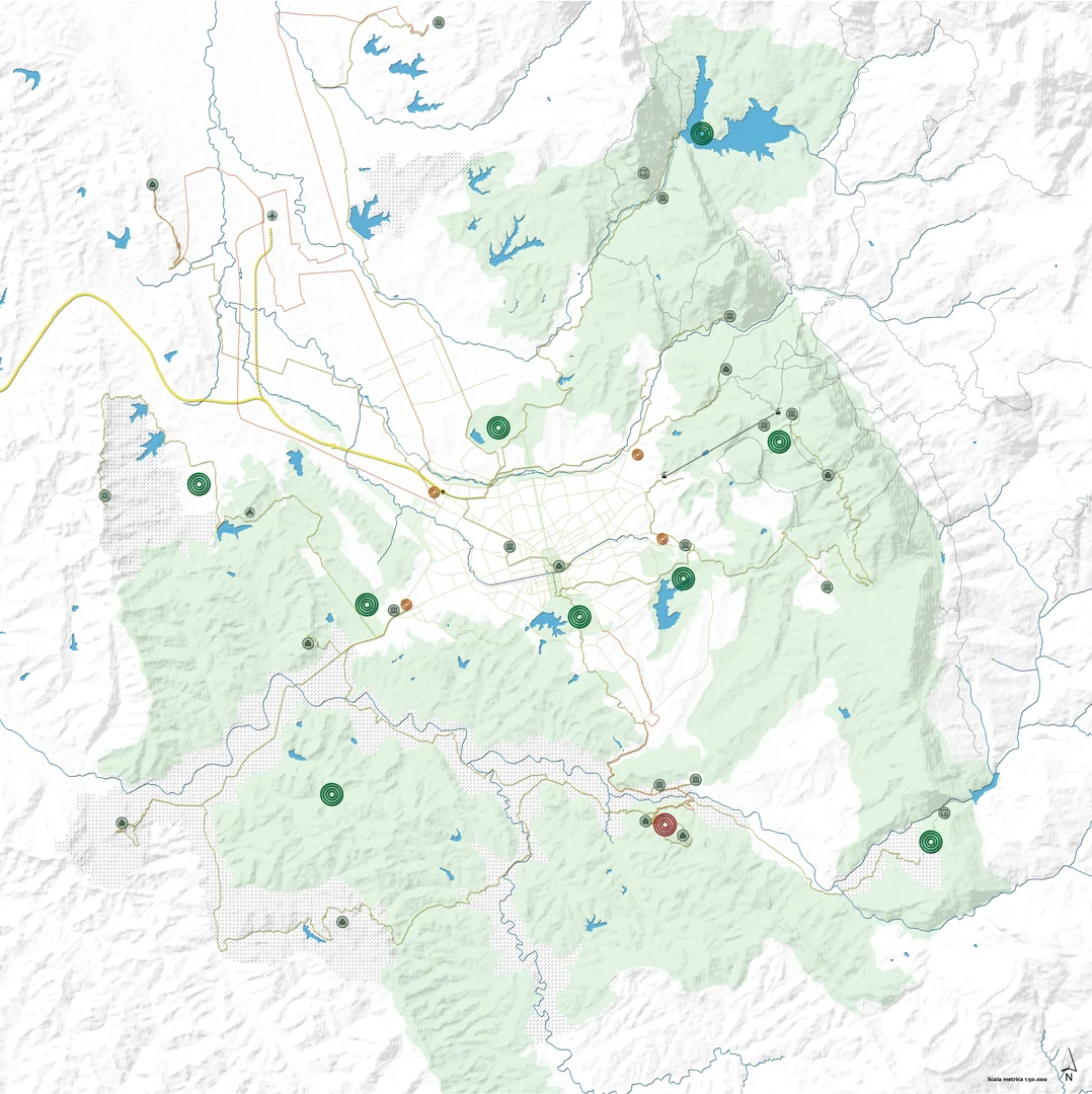
The planning idea aims at the requalification, enhancement and promotion of naturalistic heritage of the city and its surrounding area. The scheme proposed fractionates the belt in two concentric systems, the inner one related straight to the city defining its confines, and the outer one which defines the territorial fields surrounding the city. The external crown aims at the reclamation, rearrangement and promotion of several identified thematic systems complement one another: green area system, heritage and enjoyment network system, system of thematic environments. Subsequent to the recognition of these systems, the corresponding plans of action has been pinpointed. It should be stressed that the application of the ecological network’s concept is the basis of project. It is a strategic model structured in a network of naturalistic areas, which are all interrelated to guarantee the preservation of biodiversity and the conservation of ecological processes. Four types of connections have been classified to guarantee this connectivity. The 1st type concerns the natural connections of an extended area, which relate the inner green belt to the external crown and the individual natural components amongst themselves in order to guarantee the continuity, within the area, of ecological functions and biological cycles. Furthermore, it’s planned the remediation and requalification of the abundant hydrographic network to guarantee the proper hydraulic functioning. For these reasons, it is considered appropriate to expand the pre-existent confines of the green belt officially established by the Albanian Government in act n.956 del 29/12/2014, to integrate, protect and enhance the new rural and natural areas, which should be put under environmental restriction. It concerns, in particular, the Erzeni’s riverbed and Kashar lakes. The integrative choice is also combined with the recognition of multi-thematic areas distinguished for morphological, historic and social characters. The other type of connections concern the urban area: primary, secondary and tertiary connections, which not only link the different green centralities, but allow the green to penetrate within the urban fabric to constitute a wave articulated through the realization of new parks, tree-lined streets and the pre-existed green areas’ development and promotion. According to the environment’s ecological qualification, it’s planned the safeguard, enhancement and promotion of pre-existed green areas and the design of new ones, equipped with facilities and features for leisure, ecological landscaping and cultural activities. The project also involves intervention strategies to reduce the risk of landslides, through the ground resistance’s increase, as afforestation, and the creation of terracing and draining water systems. In addition, it’s planned the realization of support works and the covering of rock wall with wire meshes, to stop the wall-rock fragments’ fall. The event control and the risk management have to be regulated through the monitoring of landslide and the development of rescue plan. The green belt project is not limited to environmental rehabilitation or safeguard’s interventions, but also represents an opportunity to promote the historical, cultural and natural heritage of this area, which has been abandoned in most cases. Subsequent to data collection (during the analytical phase) and the hierarchization (during the interpretative phase), 3 types’ territorial centralities have been identified: centrality with a strong naturalistic appeal, centrality for urban equipment and centrality with a strong historical-cultural appeal. The centralities with a strong naturalistic appeal are those areas characterized by pronounced environmental and ecological qualities, in which leisure, didactic, social, cultural and touristic activities will take place. All these activities should be performed with due regard for the local characteristics, without modifying the habitat. The safeguard, restoration and development are planned for these areas. The centralities for urban equipment are those areas capable to provide a wide range of services, both urban and territorial, and which establish (according to their position) direct connection both with the green belt and its systems, and with the urban fabric. These centralities have to distinguish by a strong green “identity”, therefore it’s planned the soil remediation (especially of the abandoned industrial areas), the reuse of disused areas, the restoration and development of properties of specialized existing building. The centralities with a strong historical-cultural appeal are those areas capable to represent a reference point within the historical-cultural network; the project includes a single centrality of this kind, and that is the Archaeological historical-natural Park of Petrela. This centrality should be distinguished as a place where planning end realizing events, as cultural projects, festivals related to the suggestive area, naturalistic riches and historical testimonies. The intervention strategies on historical-cultural heritage include the recovery, promotion and in specific cases the transformation into a museum, through the realization of pedestrian paths for the accessibility, securing the site and the collocation of signage and posters necessary for the sites’ identification and description. Each single architectural structure is included into tourist and cyclist-tourist trades, integrated in a suggestive environment with naturalistic riches of exceptional value. Considering the territorial equipment pool, it’s planned the integration of the existing camping area (in the vicinity of Kashar lakes) into a thematic system specialized in sports tourism. The camping and the sports tourism are rapidly growing fields, in fact represent a great local development occasion for several cities and towns, integrating the tourist attraction of Tirana. Considering the great connecting infrastructures, it’s planned the intervention on the Rinas Airport, Dajti Ekspres funicular railway and the planning of intra-modal station of Tirana West Terminal. As far as the airport, it’ planned its integration with public transport systems, connecting in particular to Tirana west terminal; these systems are a new rail hub along the Durazzo-Tirana line and two extra-urban electric bus lines, which link Tirana to Preza and Kruja (with stops at the airport). Considering the “Dajti Ekspres” funicular railway, connecting Tirana to Dajt mount park, it’s planned its promotion and development, through the enhancement of facilities at departures and at arrivals as: signage and information signs, bike sharing, excursion and sightseeing tours, leisure equipment, facilities for skiers. The global aim is to increase the visitors number from all over the world, during each season of the year. As far as the Tirana West Terminal, it is a centre of connection between suburban and urban means of transport; in fact the railway coming from Durazzo, trams, buses and urban pedestrian-cycle paths will arrive here. This intra-modal railway will be equipped with different services and leisure equipment, perfectly integrated with the next green areas according to eco-friendly principles. Considering the mobility, it has been decided to prefer, during the planning, the eco-friendly types to enhance the environment quality, reducing the heavily polluting impact that Tirana has actually on the surrounding area. The project envisages the development of existing paths and the design of new ones. Regarding the pedestrian mobility, it’s planned the reorganization of pre-existed paths to facilitate the accessibility and the fruition of green spaces and parks, and the creation of itinerary immersed in the green and provided with signage and appropriates tools. It’s included in particular the creation of excursionist paths in the national park of Dajt and in the Pëllumbas and Bovillë cave sites to increase their tourist attraction. As far as the cycling mobility, it’s designed a dense network of paths integrated within the area, linking the city centre and the rural, historical and natural areas in response to the growing request, supporting slow mobility. Furthermore, extra-urban electric bus lines have been found to connect Tirana with important tourist centres. A connecting line between Tirana West Terminal station, the airport, Albanopolis e Kruja; another one between Tirana West Terminal station, the airport and Peza; another one between Tirana West Terminal station and Petrela. The entire railway system will be enhanced to increase the efficiency, reducing journey times and private-vehicle traffic; at the same time it’s planned the creation of an extremely well-integrated system with urban public transport, the damaged rail lines’ recovery, the modernization of very backward motor pool, the introduction of an accessible charging system (with prices that promote its enjoyment), the number increase of rails connecting Tirana to Durazzo (from 1 to 2), the electrification of rail lines, the identification of secondary stops along the way. The aim is to create a metropolis connecting to Durazzo port and airport through an efficient public transport, increasing the offers and reducing journey times and private-vehicle traffic. Last but not least 6 thematic fields have been identified: Rural life system, Petrela cultural system, Dajt natural system, Boville lake system, Kashar lake system, Historic sites system, which organize parts of the territory according to their majority vocation. The green belt’s inner crown has the role of dialoguing with the external naturalistic context and urban fabric, aimed to its recovery, reorganization and promotion through different intervention systems complementary to each other. The identified systems are characterized by their intervention field: territorial safeguard system, urban fabric system, green area and outdoor system and sustainable mobility system. According to stated objectives by PINS Tirana-Durazzo, the project aims to reduce the pollution, damaged ecosystems and to increase natural areas under environment restriction. Three hydrogeological and morphological risks have been identified in the urban field, which could compromised the life quality: landslide risk, risk of contamination with Radon and risks linked to the fluctuation of superficial groundwater. The landslide risk is localized along the hilly ridge which rounds the south plain and along the eastern slope of Shkozë. The intervention strategies for these areas are the same used for the external crown outlined above. The planning reply to the possibility of Radon contamination is designed according to an architectural scale. During the new buildings’ planning, it is recommended the adoption of a crawl space and a suction pump to prevent radon’s concentration and circulation to building floors, whereas the existing buildings could be equipped with a Radon collection sump linked to a fan, which expels gas outside the building, or a pressurization unit which opposes gas lift increasing the pressure within the building. Where the installation of these systems is not possible, it’s recommended the basement apartments’ flooring waterproofing, their ventilation’s improvement thus reducing gas concentration. Periodic monitoring operations are necessary to prevent the risk linked to the fluctuation of superficial groundwater, guaranteeing the securing of territory. The water deriving from groundwater could be used for irrigation of green areas and vegetable gardens, and for the realization of fountains and pools of water. Considering the urban fabric, in accordance with the strategic regional vision of PINS Tirana-Durazzo aiming to the improvement of urban quality no later than 2030, it’s planned the intervention on the historical Ottoman fabric which includes the preservation of buildings’ structural type features, technologies and materials (including interventions of structure consolidation), with the removal of unnecessary additions which have not an historical and architectural relevance. The private garden characterizes the buildings placed in the nineteenth-century city, qualifying the house exercise yard. Subsidies are planned to recover this urban element. The project of informal areas is more detailed. The PINS Tirana-Durazzo involves, within its implementing priorities, the informal settlements’ improvement of 80% in terms of infrastructures, integration and upgrade. Particular attention shall be given to high-density informal areas, both hilly and flat. The safeguard system of territory and the one concerning the fabric are the substratum on which the plan of green areas and outdoors is arranged. The urban green belt of Tirana is the result of composition of integrated micro-systems: the system of suburban polarities, system of connecting parts, which are divided into radial parts and annular ones, direct and indirect in their turn. The system of suburban polarities is a double system given that it identifies an urban naturalistic centrality (great regional parks) and an urban centrality for equipment pool (urban hubs). The Parku i Madh (the Tirana great park) is included in this system with new green areas designed in the vicinity of urban hubs, connecting to the green belt. The 4 urban hubs, identified are: two ex-industrial areas (Kombinat e Officina Trattori), an abandoned military area and the area of intermodal station’s project. The material green network of connection, between the suburban polarities, is realized through natural connection channels, classified differently on the basis of their importance. The indirect network of connection is accurately designed. The designed multi-coloured mapping in green tones identified a widespread and diversify intervention on green areas. The parks and public green areas have been classified on the basis of a dimensional articulation or a pronounced functional characterization: linear outdoors (green areas of variable size, which extends lengthwise); regional parks (parks approximately 300 ha in size); metropolitan parks (parks approximately 60ha in size); neighbourhood parks (parks approximately 20 ha in size); local parks and outdoors (parks approximately 2 ha in size); small outdoors (green areas approximately below 2 ha in size); national parks; green sports areas; cemetery parks. It’s planned, for these areas, the creation of new parks and the requalification of the pre-existing ones and the improvement of facilities. Green areas have been identified through the recovery of wild fields, according to different scales, capable of completing the naturalistic network and promoting ecologically the environment and the urban fabric. Within the system of intervention for urban sustainable mobility, it has been identified strategies for the great infrastructures of connection, for eco-friendly mobility and for eco-friendly motorised mobility to reduce the pollution of private means of transport, to increase the ecological quality of the great urban road routes, promoting the penetration of the green belt within the urban fabric, according to the same goals and systems described previously in the outer green belt. In addition, the urban project includes the conclusion and requalification of existing cycle paths to support the development of a slow mobility to enhance life quality and to reduce the use of private vehicles, making the city less noisy and polluted.
This network will follow the urban inner streets and the main radial aisles, which connect the centre of Tirana to the hauls of outer belt. It’s planned the reorganization and the creation of tree-lined streets to improve the appearance of the city, to guarantee the shading and to integrate nature in the urban fabric, creating uninterrupted communication routes for animal species; the existing greenways’ recovery and promotion to make the urban environment interesting from a naturalistic, historical, landscape, architectural and cultural point of view; the design of new greenways on the existing infrastructures devoid of natural equipment, as the historical streets, important urban transport routes, or along the abandoned railways; the creation of a great naturalistic network within the urban fabric. Considering the pedestrian paths, it’s planned the reorganization of the existing ones to promote accessibility and enjoyment of public spaces; the realization of footbridges in the high-density areas and in vicinity of main crossings. The aim is to improve the road safety of drivers and pedestrians, to reduce the traffic congestion, the air pollution and the obstruction due to the frequent pedestrian crossing; the creation of green itinerary, where necessary, equipped with signage and tools, within parks and small outdoors. In addition, it’s planned the development of bus line to improve the quality of public transport services and to reduce the use of private vehicles. In addition, the creation of bus dedicated lanes along the main roads and radial aisles which connect the suburbs to the Tirana centre, to realize an uninterrupted network. The project will reduce the public transport time taken and will guarantee the operative high speed of buses; it’s also planned the creation of an app which allows the passengers to plan the time of arrival and departure. Last but not least it’s planned the creation of a tramline which supports the passengers transport between the main strategic areas; the realization of North-south tramline, which leads from Tirana West terminal to Madre Teresa square (along the ancient railway, taking the monumental and axis); from East-West Line which connects Ex-Kombinat area to Kinostudio; from the line along the 3rd road ring of the city and along the 5th road ring, with some exceptions, and which connects all the polarity of the green belt.